


The following story was originally published on the International Center for Agricultural Research in the Dry Areas (ICARDA) website. ICARDA is a member of the Consortium of International Agricultural Research Centers, supported by the CGIAR Fund.
Without access to accurate and comprehensive data, decision makers and researchers struggle to develop appropriate policy agendas – they lack the information they need to determine what interventions are needed, and where, and their policies may do more harm than good, or at best, be ineffective and miss their intended targets.
Iraq is one of many countries across the Arab world that is looking to make its decision making processes more effective. After decades of conflict, sanctions, and increasing environmental degradation brought on by climate change, Iraq needs an appropriate policy agenda capable of revitalizing its struggling agricultural sector and meeting the food needs of its growing population.
In a country where government ministries and other decision making bodies face significant capacity constraints, policy reform is unlikely to be an easy task. Yet this process can be facilitated if policymakers are given reliable data on which to complement evidence-based decision making. This is the thinking behind a new online tool that aggregates a full range of development-related data – a ‘one-stop’ source of reliable and comprehensive geospatial information that targets Iraq’s policymakers and research community.
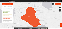
Iraq Spatial, launched in Baghdad on March 23rd, provides over 200 indicators, including macroeconomic, sectoral, climate, biophysical, and socioeconomic data at the national, subnational, and pixel level. The tool enables users to target policies where they are most needed, for instance pin-pointing which areas are more vulnerable to climate variations and climate change by mapping relevant indicators for precipitation, temperature, and biomass variability.
The tool is a collaborative effort involving the International Food Policy Research Institute (IFPRI) and the International Center for Agricultural Research in the Dry Areas (ICARDA), as part of the USAID-funded Harmonized Support for Agriculture Development (HSAD). It is also the first country portal affiliated with the more expansive Arab Spatial, a region-wide repository of geospatial information initiated by IFPRI and supported by the International Fund for Agricultural Development (IFAD) and the CGIAR Research Program on Policies, Institutions, and Markets (PIM). Iraq Spatial builds on this model to provide more specific national and sub-national level data to assist in the precise targeting of food security and development interventions.
As a free and open access knowledge platform, it allows end users to query a full range of databases, build interactive multilayer maps, and use customized analytical tools to compare, explore and download these results. It will also be updated and expanded on a regular basis and welcomes the submission of new information from partners and other stakeholders – thereby helping to continually improve the tool and further assist in the delivery of appropriate development interventions across Iraq.
Iraq Spatial is built upon a conceptual framework developed by IFPRI, termed the ‘Food Security System,’ which identifies pathways to improved food and nutrition security. This framework links the complex interaction of factors at the macro and micro levels to demonstrate how external shocks such as food price hikes or interventions in the form of policies and programs affect the availability of food and the nutritional status.
The tool also supports the work now being rolled out by the ICARDA-managed HSADinitiative to support policymakers in Iraq. Since the initiative’s inception last year, the program has supported Iraqi decision makers to identify policy and regulatory constraints, and initiated a policy and reform agenda capable of raising the country’s agricultural productivity. ICARDA and HSAD have been closely involved in the development of a national seed law, for instance, that promises to deliver quality seed to Iraqi farmers and raise their productivity.
The effectiveness of legislation such as this ultimately depends upon the quality and accessibility of the information that policymakers have to reach their decisions. Iraq Spatial raises the bar in this regard, providing a reliable and comprehensive set of data with the potential to fundamentally change the way that policies are developed.
The Iraq Spatial tool can be accessed free of charge at the following link: http://www.arabspatial.org/iraq